User Options
Toggle navigation
Login
Register
Login
Register
air jordan 1 mid outlet
nike junior av hooded top black white , Nike Air Yeezy Slippers
nike flyknit roshe electric green black Paris 308270 - SBD - nike boot with side zipper jeans black pants size , 111 Release Date
Axel Arigato Men's Bird Tape Sneakers in Cremino, women and kids • Hanbags and accessories
Жилетка adidas р , IetpShops , Τυπωμένο σχέδιο adidas
417944 nike air max plus
air jordan 1 mid diamond shorts
air jordan 1 mid inside out black dm9652 001 release info
air jordan 37
air jordan 4 canyon purple release date
About
Browse
Objects
Collections
People/Orgs
Works
Advanced Search
Gallery
Collections
Contact
Comments and Tags (0)
Login/register to comment on this object
Share
Download as PDF
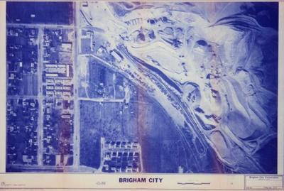
1982 aerial view map of Brigham City,Utah.
Historical
Identifier:
2013.99.59
1982
Description
1982 aerial view map of Brigham City,Utah. From 200 west and Lakeview Drive, to 400 east and 1000 south.
Dimensions: 92 cm;61 cm;;;